

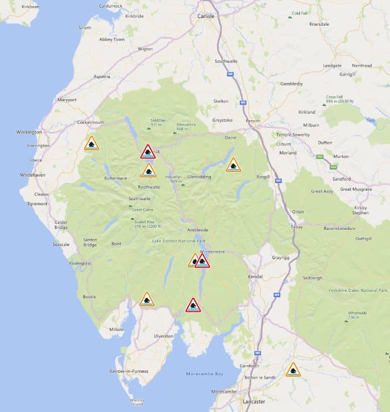
Three flood warnings and six alerts are in force in Cumbria as the county recovers from torrential downpours at the weekend.
The Environment Agency has flood warnings – which mean flooding is expected and to act now – for the following areas:
Keswick Campsite
The level of Derwentwater remains high following recent heavy rainfall, although it is now beginning to fall slowly. Further showers are expected into Monday. Areas that continue to be at risk of flooding include low-lying land bordering the shores of Derwentwater and the frontage of the Keswick Camping and Caravan Club Site.
Avoid using low-lying roads and footpaths and any bridges near local watercourses, do not attempt to walk or drive through floodwater. This flood warning is expected to remain in place for several days as the lake level will remain high.
River Leven at Newby Bridge and Backbarrow
River levels remain high following prolonged rainfall, although they are now beginning to fall slowly. Further showers are expected into Monday. Flooding is expected at properties adjacent to the River Leven at Newby Bridge and Backbarrow, including the Swan Hotel, Boat Houses, Mill Farm, The Whitewater Hotel, Water Close, Lakeland Village, Coach House and Levens Dale.
The Environment Agency will continue to closely monitor the situation. Its incident response staff are checking defences. Avoid using low-lying roads and footpaths and any bridges near local watercourses, do not attempt to walk or drive through floodwater.
Windermere (lake levels)
The level of Windermere remains high following recent heavy rainfall, although it is now beginning to fall slowly. Further showers are expected into Monday. Flooding is expected to remain a risk to low-lying commercial and residential properties, camping, caravan sites and leisure facilities on the shores of Windermere.
Avoid using low-lying roads and footpaths and any bridges near local watercourses and do not attempt to walk or drive through floodwater.
Flood alerts, which means flooding is possible and to be prepared, are in force for the following areas:
Lower River Lune and Conder
River levels remain high on the River Lune and River Conder due to rainfall. Flooding is possible at River Lune, Conder and Keer and other watercourses from Kirkby Lonsdale to Galgate including Gressingham, Carnforth, Hornby, Wray, Bentham and Lancaster from 8am today.
Further rainfall is forecast this morning. The Environment Agency is clearing debris from weed screens in the area and will continue to monitor levels closely. Avoid using low-lying footpaths and any bridges near local watercourses and do not attempt to walk or drive through floodwater.
Plan driving routes to avoid low-lying roads near rivers, which may be flooded.
Rivers Brathay, Rothay and Winster
River and lake levels remain high as a result of recent rainfall. These include Rivers Brathay, Rothay and Winster and other watercourses, particularly from Grasmere to Grange-over-Sands including low-lying areas around Ambleside, Skelwith Bridge, Windermere, Hawkshead, Newby Bridge, Backbarrow, Cark and Cartmel.
Further showers are expected into today. The Environment Agency is monitoring the situation. Avoid using low-lying footpaths and any bridges near local watercourses and do not attempt to walk or drive through floodwater.
Rivers Cocker, Marron and Derwent
River levels will remain high on the Rivers Cocker, Marron and Derwent due to recent rainfall. Consequently, the risk of flooding remains. Flooding is expected to affect low-lying land and roads in the Buttermere, Lorton Valley, Cockermouth, Branthwaite, Bridgefoot, Camerton, Barepot and Workington areas.
Further showers are expected into Monday. This will keep levels high on the River Cocker, Whit Beck, River Derwent, River Marron, Lostrigg Beck and their tributaries. The Environment Agency will continue to monitor the situation closely.
Avoid using low-lying footpaths and any bridges near local watercourses and do not attempt to walk or drive through floodwater.
Rivers Duddon, Crake and Mill Beck
River levels remain high at the Low Nibthwaite and Fitz Bridge gauges as a result of recent rainfall. Consequently, flooding of roads and farmland remains possible. Flooding is expected to affect low-lying land and roads in the Dunnerdale, Duddon Bridge, Broughton-in-Furness, Kirkby-in-Furness, Soutergate, Coniston, Ulverston, Dalton-in-Furness and Barrow-in-Furness areas.
High river and lake levels are possible on the River Duddon, Kirkby Pool, Soutergate Beck, Church Beck, Yewdale Beck, Coniston Water, River Crake, Town Beck, Dragley Beck, Poaka Beck, Mill Beck and their tributaries. Further showers are expected today.
Rivers Lowther and Eamont
River and lake levels are high as a result of persistent heavy rainfall over the last few days. Consequently, the risk of flooding remains. Flooding is expected to affect low-lying land and roads in the Bampton, Patterdale, Glenridding, Dockray, Pooley Bridge, Dacre, Eamont Bridge and Penrith areas.
High river and lake levels are still possible on the River Lowther, Haweswater Beck, Goldrill Beck, Grisedale Beck, Glenridding Beck, Aira Beck, Ullswater, River Eamont, Dacre Beck, Thacka Beck and their tributaries.
Further showers are expected into today. The Environment Agency is closely monitoring the situation. Avoid using low-lying footpaths near rivers and plan driving routes to avoid low-lying roads which may be flooded.
Upper River Derwent, Stonethwaite Beck and Derwentwater
Water levels remain high on the Upper River Derwent, Stonethwaite Beck, Derwentwater and surrounding watercourses as a result of recent heavy rain. Flooding is likely to affect low-lying land in locations near the Upper River Derwent, Stonethwaite Beck and Derwentwater.
Avoid using low-lying footpaths near these watercourses and do not attempt to walk or drive through floodwater. Further showers are expected into Monday.


