


KEEP UP-TO-DATE WITH LIVE UPDATES HERE
The Met Office has issued updated weather warnings for today and tomorrow.
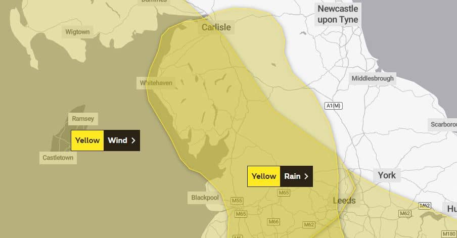
Today, it says very strong winds may cause disruption across Irish Sea coasts, south west Scotland and Northern Ireland, particularly tonight.
Strong winds are expected to develop during this afternoon across Northern Ireland and southwest Scotland, extending into parts of North West England and north Wales during the evening, with inland areas likely to see gusts of 50-60mph and up to 70mph on exposed coasts and hills.
However, a swathe of very strong winds is possible for a time overnight into Monday morning, bringing a chance of inland gusts of 60-70mph and 80mph on exposed coasts and hills.
What to expect
- There is a slight chance of some damage to buildings, such as tiles blown from roofs
- There is a small chance that injuries and danger to life could occur from large waves and beach material being thrown onto sea fronts, coastal roads and properties
- There is a chance of longer journey times or cancellations as road, rail, air and ferry services are affected
- There is a slight chance that power cuts may occur, with the potential to affect other services, such as mobile phone coverage
A yellow weather warning for rain is also in force until 6pm.
The Met Office says heavy rain rain is expected to lead to some disruption.
It says an area of heavy rain will affect parts of northwest England on Sunday and become slow-moving for a time with some very heavy rain, especially over high ground.
The duration and intensity of the rainfall could bring widespread totals of 20 to 40mm, but some exposed sites may see 60 to 80mm – however – this will fall on to already-saturated ground. The rain should clear south by the evening.
What to expect
- Spray and flooding could lead to difficult driving conditions and some road closures, causing delays or cancellations to train and bus services
- There is a chance that homes and businesses could be flooded, causing damage to some buildings
- There is a small chance that some communities will become cut off by fast flowing or deep floodwater
- There is a slight chance of power cuts and loss of other services to some homes and businesses
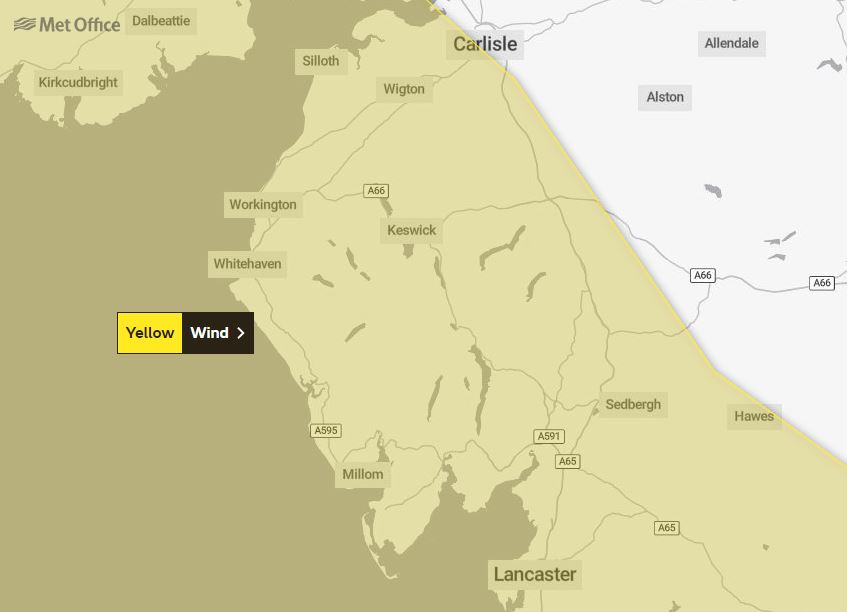
Tomorrow, the yellow weather warning for wind says strong winds are expected to develop during this afternoon across Northern Ireland and southwest Scotland, extending into parts of North West England and north Wales during the evening, with inland areas likely to see gusts of 50-60mph and up to 70mph on exposed coasts and hills.
However, a swathe of very strong winds is possible for a time overnight Sunday into Monday morning, bringing a chance of inland gusts of 60-70mph and 80mph on exposed coasts and hills.
What to expect
- There is a slight chance of some damage to buildings, such as tiles blown from roofs
- There is a small chance that injuries and danger to life could occur from large waves and beach material being thrown onto sea fronts, coastal roads and properties
- There is a chance of longer journey times or cancellations as road, rail, air and ferry services are affected
- There is a slight chance that power cuts may occur, with the potential to affect other services, such as mobile phone coverage
Flood alerts
19 flood alerts are in place for Cumbria:
- Coast at Barrow in Furness
- Coast at Duddon estuary
- Coast at North Morecambe Bay
- Coast from Gretna to Silloth
- Coast from Silloth to St Bees
- Coast from St Bees Head to Millom
- Lower River Lune and Conder
- Rivers Brathay, Rothay and Winster
- Rivers Caldew and Petteril
- Rivers Duddon, Crake and Mill Beck
- Rivers Kent and Bela
- Upper River Aire catchment
- Upper River Derwent, Stonethwaite Beck and Derwent Water
- Upper River Eden
- Upper River Lune
- Upper River Ribble, Hodder
- Upper River Ure
- Upper River Wharfe
- Upper River Wyre, Brock
The Environment Agency has removed the flood warning for the Cumbrian coastline from Silloth to St Bees including Maryport, Flimby, Workington and Whitehaven.
Power
Electricity North West is reporting that 25 people are without power in Blackford, near Carlisle and the time of restoration is under review.
Travel
A number of train companies are still recovering from major damage to the railway and obstructions on the line.
Network Rail said it had additional engineers out across the network dealing with the continuing problems, and will check all affected lines for damage before reintroducing services as quickly as possible.
Northern is reporting no issues and Avanti West Coast said due to the strong winds and heavy rain forecast there may be some changes and delays to services.
Emergency speed restrictions will be imposed in Scotland until tomorrow morning. and as a result, journeys to/from Glasgow and Edinburgh will be extended by around 22 minutes.
Trains are also expected to be busy as people rearrange their journeys because of storms Dudley and Eunice and passengers are urged to check before they travel and make their journey at quieter times, if possible.


