


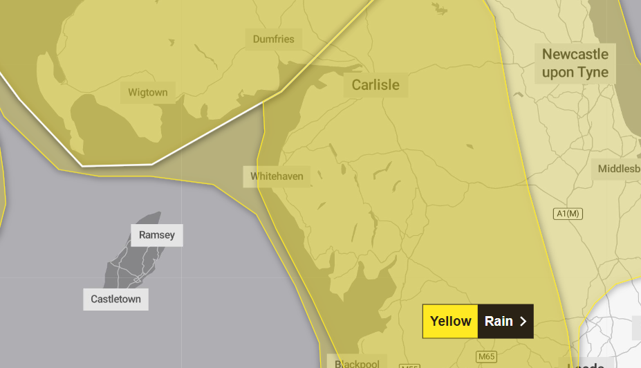
Cumbria is set to be battered by Storm Amy this weekend.
The Met Office has issued yellow weather warnings for very strong winds from 3pm today Friday 3 October until midnight on Saturday 4 October as well as heavy rain from 3pm today until midnight.
It said the storm is expected to develop rapidly as it approaches the UK today – bringing strong stormy weather to northern and western areas of the country.
Gusts of up to 60mph are likely for many areas and may reach up to 70mph in some places. Exposed coasts and hills will see the highest gusts, which could exceed 80mph.
The strong winds will also come with heavy rain, which the weather forecaster said is likely to lead to travel disruption and some flooding.
Driving conditions across the country are also expected to be difficult for high sided vehicles on prone routes such as cross winds or on exposed high level routes.
The winds will ease for most areas on Saturday afternoon but will continue to be very strong for the Northern Isles and parts of the far north of Scotland through to the end of the day before slowly easing overnight.
Heavy rain will arrive on Friday afternoon and continue into the evening, with a small period of very heavy rain in the evening likely.
During this time 10mm to 20mm of rain will fall widely, with 40mm to 70mm over areas of high ground exposed to the southwesterly winds. Around 15 to 20mm could fall within one hour in some places.
Drier conditions will follow on Saturday morning, although a few short-lived heavy showers will remain in parts.
Storm Amy is the first named storm of the 2025/26 season and the Met Office said its evolution is being closely monitored.
It added that the storm’s development is being influenced by the remnants of Hurricanes Humberto and Imelda over the tropical Atlantic.
The forecaster said these systems have accelerated the jet stream, contributing to the formation and intensification of Storm Amy.
Cumbria police are asking people to plan ahead and stay safe during the storm by doing the following:
- Secure loose items around your home and garden
- Check in with vulnerable relatives, friends & neighbours
- Charge phones and check torch batteries
- Park vehicles safely away from trees and buildings
- Stay away from coastal areas and the fells
- Never drive through flood water
- Avoid downed power lines or cable
The council is also advising residents to check Met Office, Environment Agency, Electricity North West and United Utilities for updates.
Highways teams and Electricity North West engineers and call centre staff are on standby.
If Storm Amy arrives, the Cumbria Crack team will be here, bringing you all the information you need.
What should I expect?
- Some damage to buildings, such as tiles blown from roofs, could happen
- Power cuts may occur, with the potential to affect other services, such as mobile phone coverage
- Injuries and danger to life from flying debris are possible
- Injuries and danger to life could occur from large waves and beach material being thrown onto sea fronts, coastal roads and properties
- Some roads and bridges may close
- Road, rail, air and ferry services may be affected, with longer journey times and cancellations possible
- Bus and train services probably affected with journey times taking longer
- Spray and flooding on roads probably making journey times longer
- Flooding of a few homes and businesses is likely
- Some interruption to power supplies and other services likely
Roads
Highways teams across Cumbria are preparing for potential wind-blown trees and other debris which may affect roads.
Emergencies on the highway that require immediate attention such as a fallen tree or flooding can be reported to the Highways Hotline on 0300 373 3306.
For less serious issues in Westmorland and Furness, complete the highways online reporting form here.
In Cumberland, you can report issues online here.
People who are travelling during the storm are encouraged to do the following:
- Plan your journey and allow extra time in case you come across any flooding or fallen trees/branches or other debris on the road
- Never drive through a road closure, take an alternative route, road closures are there for your safety
- Do not drive through flood water, only a small amount of water could damage your engine and cause you to get stuck and need help
Rail
Rail passengers have been urged not to travel as the North West gets ready for the arrival of Storm Amy.
TransPennine Express has issued do not travel advice due to the gale force winds expected.
There are a number of amber and yellow weather warnings in place across Scotland and North West England, any trains that are able to run are expected to be affected by delays and short notice cancellations.
The rail operator is urging customers not to travel on the following routes today, October 3:
- Preston-Edinburgh: from noon
- Newcastle-Edinburgh: from 4pm
- Preston- Glasgow: from 5pm
Customers are advised not to travel until noon tomorrow, Saturday October 4 on the Preston to Glasgow/Edinburgh route and the York to Newcastle route.
Passengers travelling after noon tomorrow are strongly advised to check before they travel.
Customers with tickets across the affected routes can defer their journey until Sunday for no extra cost.
Avanti West Coast is advising people to travel as early as possible today, Friday October 3.
Power
Electricity North West engineers and call centre teams are on standby.
The provider said due to the high wind speeds predicted, damage to overhead electricity lines is possible from flying debris as well as falling trees and branches, with trees still in full leaf.
Conditions may not be safe for teams to climb poles and repair damage until wind speeds decrease through the weekend.
Alan Astall, head of network control at SP Electricity North West, said: “Our preparation plans are well-rehearsed and we’re ready to respond if needed this weekend. We know strong winds can be disruptive by blowing debris into overhead lines despite our work year round to cut trees away from lines.
“Our main priority is safety so if you do notice any damage to the network, for example damaged overhead lines or electricity poles, contact us immediately by calling 105.
“If you or someone you know could be adversely affected by a power cut, you can join our free Extra Care register for additional help and support.
“We monitor the forecast daily and actively manage the power network 24/7, 365 days a year.
“When bad weather is forecast, we scale up our preparations so we can respond quickly.
“We prepare throughout the year, from cutting trees to installing new technology which helps identify network issues and restore power faster to reduce the impact on customers.”
Find out more about the Extra Care register here.
Where can I report any issues?
- Electricity North West can be contacted on 105 for power cuts, but only call if your query is urgent to help prioritise customers in the most vulnerable circumstances.
- For water supply issues contact United Utilities on 0345 672 3723.
- Problems with the roads in Cumberland can be reported to Cumberland Council via the council’s website www.cumberland.gov.uk or, in an emergency, on the Highways Hotline on 0300 373 3736.
- For Westmorland and Furness, report highways emergencies that require immediate attention such as a fallen tree or flooding to the authority’s Highways Hotline on 0300 373 3306. For less serious issues, complete the highways online reporting form found at westmorlandandfurness.gov.uk
- Contact www.cumbria.police.uk/report-it or call 101 if you have concerns about your own safety and well-being, or the safety and well-being of someone you know. If there is an immediate risk to life call 999.
Why should I care about weather warnings?
Weather warnings are issued to let people know what weather is in store for their area and what its impact could be.The Met Office is the UK’s official weather service and is responsible for issuing weather warnings to the public.
There are three main levels of weather warning:
- Yellow – which asks people to be prepared for disruption
- Amber – which asks people to change plans that could be impacted by the weather and take action to protect themselves and their property
- Red – which is issued for weather that poses a danger to life and asks people to immediately take direct action to keep themselves and others safe from impacts of the weather
Yellow and amber warnings represent a range of impact levels and likelihoods. This means it is important to read each warning to know what level of impact to expect in your local area – and how likely those impacts are to occur.
The Met Office began issuing impact-based warnings in 2011 – which means that warnings are issued when the weather may have an impact on people’s day to day lives.
Previous to this, warnings were issued to the public when certain weather thresholds or levels were reached.
Impact-based warnings take multiple factors into account – these include time of day, if it may impact traffic, time of year, if the weather is unusual, if there are any seasonal events taking place and if the area is well equipped to deal with the weather.
Each warning level is designed to help people take steps to minimise the chances of disruption in their lives.
Why do the Met Office name storms in the UK now?
The Met Office started naming storms in 2015 as part of its storm naming protocol, which aims to improve public awareness and readiness for impactful weather.
Storms are named in the UK when it has the potential to cause disruption or damage which could result in an amber or red warning.
The naming is combined with the Met Office’s severe weather warning service, which combines the impact the weather may have and the likelihood of that impact occurring.
Storms are usually named on the basis of the impact from strong winds, but other weather types like rain or snow, are considered, as they can lead to flooding.
The Met Office complies a list of storm names from public suggestions and from Met Éireann and KNMI. It chooses some of the more popular names and names that reflect the diversity of the UK, Ireland and the Netherlands.


