


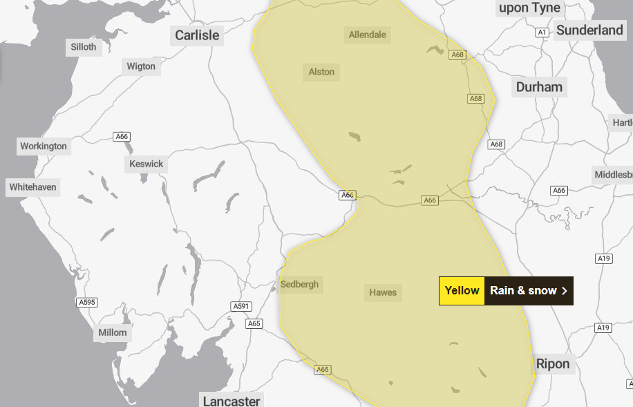
A weather warning for rain and snow has been issued for parts of Cumbria today as Storm Chandra hits the UK.
The Met Office has issued the yellow weather warning from midnight until 5pm today, Tuesday January 27.
The Met Office said outbreaks of rain were due to spread northwards last night into this morning, falling as snow on high ground.
Rainfall accumulations of 20mm to 30mm were likely fairly widely with 40mm to 50mm possible in places.
Totals may accumulate fairly quickly in parts of the southern Pennines and southwest Scotland, which could see accumulations of 20mm in a three-hour period.
Whilst accumulating snow is unlikely at low-levels, there will be a sharp increase in snow depths with elevation, with the potential for 2cm to 5cm in places above about 300m, 5cm to 10cm above 400m, and 10cm to 20cm above 500m.
This may impact some high-level routes, with drifting possible in rather brisk south easterly winds.
Strong, gusty winds, especially to the west of hills, may exacerbate the potential for transport disruption.
Roads
- National Highways has closed the snow gates eastbound at Brough from 4am today due to the predicted snow. It said it had done so as a precautionary measure to ensure the safety of road users.
- A West Cumbrian road is closed due to a fallen tree. The road is closed from the junction of Lakeland Avenue at The Ginns in Whitehaven to Monkwray Brow in Kells. Drivers are asked to avoid the area while the road is made safe. Cumbria police said the school can be accessed via Monkwray Brow without an issue.
- The Brough to Middleton-in-Teesdale road is impassable due to heavy snowfall. Westmorland & Furness Council said the B6276 was blocked following heavy snowfall in the last couple of hours. The authority said its crews were out to clear it and other routes around Alston.
Power cuts
Hundreds of homes are without power in Cumbria.
SP Electricity North West said engineers were either on site or on their way to fix the issues.
Areas affected
- Arnside, South Lakeland – 218 properties affected. Estimated time of restoration 12.17pm
- Morland, Eden – 27 properties affected. Estimated time of restoration 11.49am
- Egton with Newland, South Lakeland – 72 properties affected. Estimated time of restoration 11.12am
- Bothel and Threapland – 69 properties affected. Estimated time of restoration 10.32am
- Dean, Allerdale – 22 properties affected. Estimated time of restoration 1.24pm
- Heversham, South Lakeland – 98 properties affected. Estimated time of restoration 2pm
- Lindale and Newton-in-Cartmel, South Lakeland 56 properties affected. Estimated time of restoration 1.45pm
- Bewcastle, Carlisle – 50 properties affected. Estimated time of restoration 11.37am
- Arnside, South Lakeland – 496 properties affected. Estimated time of restoration 10am
- Waberthwaite, Copeland – 69 properties affected. Estimated time of restoration 12.14pm
What should I expect?
- Some roads and railways likely to be affected with longer journey times by road, bus and train services
- Some interruption to power supplies and other services likely
- Bus and train services probably affected with journey times taking longer
- Spray and flooding on roads probably making journey times longer
- Flooding of a few homes and businesses is likely
Why should I care about weather warnings?
Weather warnings are issued to let people know what weather is in store for their area and what its impact could be.The Met Office is the UK’s official weather service and is responsible for issuing weather warnings to the public.
There are three main levels of weather warning:
- Yellow – which asks people to be prepared for disruption
- Amber – which asks people to change plans that could be impacted by the weather and take action to protect themselves and their property
- Red – which is issued for weather that poses a danger to life and asks people to immediately take direct action to keep themselves and others safe from impacts of the weather
Yellow and amber warnings represent a range of impact levels and likelihoods. This means it is important to read each warning to know what level of impact to expect in your local area – and how likely those impacts are to occur.
The Met Office began issuing impact-based warnings in 2011 – which means that warnings are issued when the weather may have an impact on people’s day to day lives.
Previous to this, warnings were issued to the public when certain weather thresholds or levels were reached.
Impact-based warnings take multiple factors into account – these include time of day, if it may impact traffic, time of year, if the weather is unusual, if there are any seasonal events taking place and if the area is well equipped to deal with the weather.
Each warning level is designed to help people take steps to minimise the chances of disruption in their lives.


