


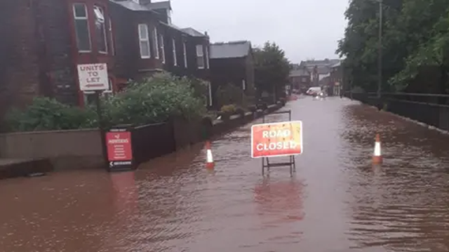
Flooding of around 80 Wigton properties last November was not a direct result of a firm’s security fence.
The town experienced a deluge of unexpected rain overnight on November 12 and November 13, which caused becks to break their banks and properties to flood.
Over 60mm of rainfall was recorded during the event, over half the average monthly rainfall for November.
In the aftermath, residents of Burnside said they feared a 6ft fence erected by the nearby CCL Secure was to blame.
Penrith & Solway MP Markus Campbell-Savours met with the residents and tabled an Early Day Motion in the House of Commons about the issue.
However, a 67-page flood investigation report published this week has found that the fence was not to blame.
Cumberland Council has a statutory duty to publish a report for areas affected by flooding. The report does not have to provide solutions and does not provide a mandate to undertake work.
Black Beck, which is not under the oversight of the Environment Agency, overtopped its banks as a direct consequence of the extremely high water levels as on the River Wiza combined with the unforeseen and intense rainfall.
The report said: “The exceptional rainfall significantly increased surface runoff and catchment inflows, overwhelming the channel capacity of Black Beck.
“This response was amplified by the antecedent wet conditions, leaving little storage within the system and resulting in rapid inundation of adjacent low-lying areas.
“CCTV footage clearly shows the fence having some impact on the flows along with vegetation that has been allowed to establish in the vicinity and adjacent to the watercourse.”
However, it added “Concerns were raised by residents that the fence restricted flow conveyance, resulting in water backing up and surcharging at the exceedance point on Ellen Close.
“A site inspection was undertaken by council officers to investigate this claim. Levels were measured using wrack marks identified by residents and were compared with the level of the exceedance point on Ellen Close.
“Water levels and wrack at the fence outside number 76 would have needed to be approximately 1.7 m higher for flooding to have affected the exceedance point on
Ellen Close.
“It is therefore concluded that the fence did not cause or contribute to surcharging at the exceedance point on Ellen Close during the event.”
As part of this report, an investigation was independently carried out on behalf of CCL Secure.
It said: ““The conclusion of this investigation is that in this case the security fence did influence the flood flows in places but didn’t impact on the flooding to the four properties.”
It added that the main contributor to the flooding of the properties was Black Beck spilling into Ellen Close from under the railway line before
building up and flowing into Wampool Place.
It said: “The flows then accumulated in Wampool Place, rising to a level that allowed flows through the gardens of 32 and 34, before joining the water
already in the flooded back gardens of the affected properties.”
Weather forecasts leading up to the event had given limited indication that a flood event of the magnitude experienced was likely overnight.
Much of the town was affected as Wiza Beck and Speet Gill flooded.
The fire station and post office were flooded.
The report said: “Water flowing through the post office site bypassed the flood prevention measures on the entrance to Slater’s Yard and passed through the yard but at a depth below the threshold levels of the caravans and chalets on the site.
“At the downstream end of the yard it is possible that water was flowing from both directions.”
The report noted that the area around Burnfoot and the ATS garage had been subject to frequent flooding over the years.
Speet Gill goes through a series of tight corners and runs under a highways culvert beneath King Street. The Strand runs under the Lidl site via an inlet structure/grid.
The report said: “The combination of high flows on Speet Gill, the tight corners the river has to negotiate and the constriction posed by the existing highways culvert have elevated levels in this part of the town.
“Water left the Speet Gill channel and flooded across the ATS site, across the roundabout on King Street, into the Lidl car park, along Strand Terrace and also down The Stampery.
“It is not evident that The Strand watercourse left the channel upstream of the Lidl store. Anecdotal information suggests that water from King Street ran along the rear of Strand Terrace and possibly entered properties from the rear as opposed/in addition to the front.”
It added that it was not clear how far east along King Street the flooding extended. It added: “Depths in properties varied but wrack marks and photographs suggests depths of up to 300mm in properties.
“Downstream of King Street allotments, roads and fields were extensively flooded. Flooding appears to have got close to properties along The Stampery but not actually entered properties.
“A number of properties in this part of Wigton already have flood prevention measures but it is not clear that they were all deployed in time or indeed if they were effective.”
It added that existing earth banks at the rear of the WCF store were sufficient to prevent extensive flooding in that part of town.
It said in Tenters, the area between the edge of Wigton and Burnfoot, Speet Gill runs along the left side of the road from about halfway along the street.
It added: “There is very limited channel capacity and road access crossings have limited freeboard.
“In addition, Speet Gill takes an almost 90 degree turn on reaching the roadside. The combination low bridge crossings, tight bends in the channel and low channel sides results in water leaving the channel and flowing across the road towards residential properties.”
The report recommends next steps, including community resilience – encouraging people to use flood resilience measures – and further investigations of drainage systems.
Cumberland Council said it was continuing to work closely with the Environment Agency and other partners to better understand the event and support communities in becoming more resilient to flooding in the future.


