A £3.4 million pothole prevention scheme is starting in parts of Cumbria.
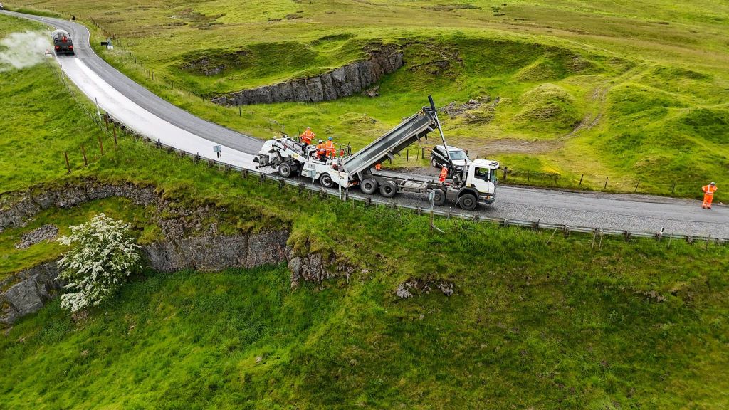
Westmorland & Furness Council said it had invested the cash in the work which, by the end of next month, will see 67 miles of road sealed with a treatment that improves the carriageway surface and delays the development of potholes for up to 10 years.
It said surface dressing significantly extended the lifespan of a road by sealing the surface to prevent water from seeping in.
It added: “It protects treated roads from freezing and wet winter weather, the leading cause of road damage across the area, which typically becomes visible in spring as temperatures begin to rise.
“The roads included in this year’s programme have already been prepared and permanently patched, ready for the surface dressing to be applied.”
Over the coming weeks, more than 650,000 square metres of road surface will be improved, the authority said.
Minimal delays are expected while the work is being carried out and traffic is immediately allowed on to the new surface, at a reduced speed, to help embed the chippings into the road. Once complete, the roads receive new markings following the final sweep, which takes place seven days after completion.
Eden area
Roads in the Eden area under the programme include:
- C3088 St John’s Road, Stainton
- C3043 Scarside to Knipe Junction
- C3053 South West of Towcett Crossroads to A6
- B6261 M6 Junction 39 Shap Toll Bar
- U3262 Andrew Scar, Great Asby
- B6259, A685 Junction to Beckfoot Junction
- C3059 Bolton to Colby
- C3004 Hanginshaw to Clickahm, Appleby
- C3087 Tan Hill, Gate House to Long Band
- B5305 Skelton, BBC Junction to Holly Hill
- C2045, B5305 Junction to Millhouse Bridge
- B5305 Newlands Mill Junction to area boundary
- C2049, B5305 Junction to Newlands Mill
- C2049 Newlands Mill to Hesket Bridge area boundary
- A686 Melmerby Moor
- B6277 Shieldhill Plantation to The Old Police Station, Alston
- A6 Penrith North, 30mph signs to Stoneybeck Roundabout
- B5350 Catterlen Roundabout to Hutton-in-the-Forest
- C3047 Cliburn North West, 30mph signs To Cliburn Mill Bridge
Furness area
Roads in the Furness area under the programme include:
- C6003 Long Lane, Dalton in Furness
- C6012 Duke Street (Schneider Square Roundabout to The Strand)
- U6011 Duke Street, Askam-in-Furness
- U6030 Chapel Street, Dalton-in-Furness
- U6085 Lumley Street (Rawlinson Street to side of 37 Marsh Street)
- U6103 Hawthwaite Lane, Barrow-in-Furness
- U6115 Oak Lea Road, Barrow-in-Furness
- U6116 Parkhouse Road (Manor Road to Newton Road)
- U6128 Bank Lane, Barrow-in-Furness
- U6215 Farm Street, Barrow in Furness
- U6216 Ramsden Dock Road, Barrow-in-Furness
South Lakeland area
Roads in the South Lakeland area under the programme include:
- B5277 Meathop Road to C5046, The Gill
- B5277 Allithwaite Road
- C5041 Cark to Cartmel
- C5042/U5693 Haggs Lane to Cartmel Road
- C5041 Longlands Farm to Field Broughton
- C5046 Back o the Fell Road
- B5271/C5046 The Gill to Lindale Brow
- C5076 Heaves Lodge to Whitegate
- C5059 Levens Lane
- B5286 Outgate to Clappersgate
- A591 Dunmail Raise
- A592 Longtail Hill to B5360
- B5360 Jct A592 to Jct A5074
- B5285 Lake Bank Coach House to Windermere Ferry
- A6070 Crooklands roundabout to Dukes Bridge
- B5282 The Strands to Arnside
- A684 Green Bank Barn to Beehive Lane
- A684 Windy Hill Farm to Park Road
- C5105 Busk Lane, Sedburgh
- A592 Newby Bridge Roundabout to Fell Foot
- A5284 Windermere Road