


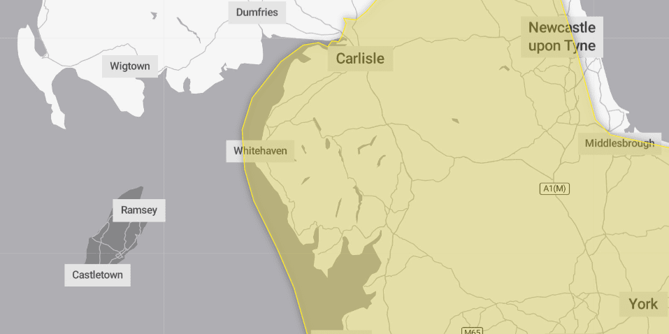
Cumbria is heading towards a big freeze this weekend as weather warnings are issued for snow and ice.
The Met Office has issued a warning for snow and ice from 4pm today, January 1, until 11.59pm on Sunday January 5.
It said icy conditions are expected widely across the county and over the weekend, heavy snow, and some freezing rain in places, may cause some disruption.
In addition, as milder air moves northwards, snow may turn to a spell of freezing rain for a time, again more especially across parts of Wales, the Midlands and northern England, adding to the risk of ice and leading to some treacherous conditions in places. A fairly rapid thaw of lying snow is possible later on Sunday, although exactly how far north the rapid thaw will reach remains uncertain at this stage.
It said outbreaks of rain spreading north eastwards later on Saturday and overnight into Sunday will likely be preceded by a spell of snow on its northern flank.
While there is a fair bit of uncertainty as to how far north this may spread, and how long any snow will last, significant accumulations of snow are possible, especially (but not exclusively) on hills.
Currently, parts of the Midlands, Wales and northern England are most at risk of disruption, where 5cm or more could accumulate fairly widely, with perhaps as much as 20cm-30cm over high ground of Wales and/or the Pennines.
This, accompanied by strengthening winds, may lead to drifting of lying snow.
In addition, as milder air attempts to move northwards into southern and central areas, snow may turn to a spell of freezing rain for a time, adding to the risk of ice and treacherous conditions in some areas.
A fairly rapid thaw of lying snow is possible later on Sunday, although exactly how far north the rapid thaw will reach remains uncertain at this stage.
However, the Met Office added: “Given the uncertainties, it is quite likely this warning area and start/end times will be refined over the coming days as confidence increases in areas most likely to be impacted.”
What should I expect?
- There is a small chance that power cuts will occur and other services, such as mobile phone coverage, may be affected
- There is a slight chance that some rural communities could become cut off
- A small chance of injuries from slips and falls on icy surfaces
- There is a chance of travel delays on roads with some stranded vehicles and passengers, along with delayed or cancelled rail and air travel
Why should I care about weather warnings?
Weather warnings are issued to let people know what weather is in store for their area and what its impact could be.
The Met Office is the UK’s official weather service and is responsible for issuing weather warnings to the public.There are three main levels of weather warning:
- Yellow – which asks people to be prepared for disruption
- Amber – which asks people to change plans that could be impacted by the weather and take action to protect themselves and their property
- Red – which is issued for weather that poses a danger to life and asks people to immediately take direct action to keep themselves and others safe from impacts of the weather
Yellow and amber warnings represent a range of impact levels and likelihoods of. This means it is important to read each warning to know what level of impact to expect in your local area – and how likely those impacts are to occur.
The Met Office began issuing impact-based warnings in 2011 – which means that warnings are issued when the weather may have an impact on people’s day to day lives.
Previous to this, warnings were issued to the public when certain weather thresholds or levels were reached.
Impact-based warnings take multiple factors into account – these include time of day, if it may impact traffic, time of year, if the weather is unusual, if there are any seasonal events taking place and if the area is well equipped to deal with the weather.
Each warning level is designed to help people take steps to minimise the chances of disruption in their lives.


